About Wasatch Backcountry Skiing Map
The Wasatch Backcountry Skiing Map is the iOS version of the popular paper map and website (visit WBSkiing.com). As with the other platforms, the iOS map includes an index to more than 1,000 backcountry locations in...
The Wasatch Backcountry Skiing Map is the iOS version of the popular paper map and website (visit WBSkiing.com). As with the other platforms, the iOS map includes an index to more than 1,000 backcountry locations in Utah’s Central Wasatch mountains. It is the must-have app for Utah hikers and backcountry travelers.
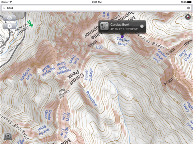
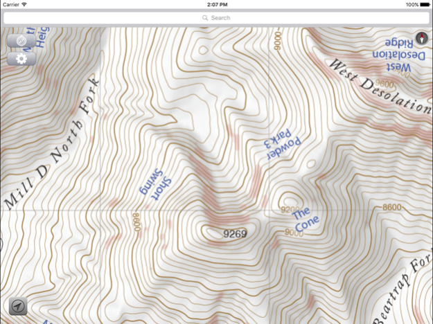
With a familiar map-app interface, the Wasatch Backcountry Skiing Map accesses your device’s GPS to display your current location on a high-resolution topo map. And with only a few taps, the “destination arrow” on the integrated compass will point to your desired backcountry ski location.
And with a single tap, hundreds of the locations will open the Wasatch Backcountry Skiing Guide website where you can view photographs and detailed information about the location.
The app also displays your current elevation and lat/long, and will send your current location via email. And with a tap, you can display detailed information on more than 200 of the locations including skiing difficulty, skinning distance, vertical climb, parking considerations, and more.
(Contrary to a posted review, you don't need cell service to use this app--you don't even need a contract with a cell service provider.)
NOTICES: When navigating, the “destination arrow” points directly to the destination without regard to hazards such as avalanche paths, cliffs, and rock fall. It is your responsibility to travel in the backcountry safely.
Dec 11, 2017
Version 3.5.0
This app has been updated by Apple to display the Apple Watch app icon.
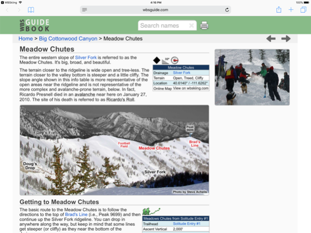
Version 3.5.0 is now linked to the Wasatch Backcountry Skiing Guide. After selecting any of the hundreds of linked-locations in the app and tapping on the "Tap here for more ..." box, photographs and detailed information about the location such as skiing difficulty, skinning distance, vertical climb, altitude, aspect, and slope angle will be displayed in Safari (see screenshot). You can tap on the "WBSkiing" text in the top-left corner of Safari to return to the app. Version 3.5.0 also has a new base-map with dozens of additions and improvements. As always, it's a free upgrade.
Previous Versions
Here you can find the changelog of Wasatch Backcountry Skiing Map since it was posted on our website on 2016-09-29 01:55:57.
The latest version is 3.5.0 and it was updated on 2024-04-19 18:20:01. See below the changes in each version.
Wasatch Backcountry Skiing Map version 3.5.0
Updated At: 2017-12-11
Changes: 11 Dec 2017 Version 3.5.0
Version 3.5.0 is now linked to the Wasatch Backcountry Skiing Guide. After selecting any of the hundreds of linked-locations in the app and tapping on the "Tap here for more ..." box, photographs and detailed information about the location such as skiing difficulty, skinning distance, vertical climb, altitude, aspect, and slope angle will be displayed in Safari (see screenshot). You can tap on the "WBSkiing" text in the top-left corner of Safari to return to the app. Version 3.5.0 also has a new base-map with dozens of additions and improvements. As always, it's a free upgrade.
Wasatch Backcountry Skiing Map version 3.5.0
Updated At: 2017-12-11
Changes: Dec 11, 2017 Version 3.5.0
This app has been updated by Apple to use the latest Apple signing certificate.
Version 3.5.0 is now linked to the Wasatch Backcountry Skiing Guide. After selecting any of the hundreds of linked-locations in the app and tapping on the "Tap here for more ..." box, photographs and detailed information about the location such as skiing difficulty, skinning distance, vertical climb, altitude, aspect, and slope angle will be displayed in Safari (see screenshot). You can tap on the "WBSkiing" text in the top-left corner of Safari to return to the app. Version 3.5.0 also has a new base-map with dozens of additions and improvements. As always, it's a free upgrade.
Wasatch Backcountry Skiing Map version 3.5.0
Updated At: 2017-12-11
Changes: Dec 11, 2017 Version 3.5.0
This app has been updated by Apple to display the Apple Watch app icon.
Version 3.5.0 is now linked to the Wasatch Backcountry Skiing Guide. After selecting any of the hundreds of linked-locations in the app and tapping on the "Tap here for more ..." box, photographs and detailed information about the location such as skiing difficulty, skinning distance, vertical climb, altitude, aspect, and slope angle will be displayed in Safari (see screenshot). You can tap on the "WBSkiing" text in the top-left corner of Safari to return to the app. Version 3.5.0 also has a new base-map with dozens of additions and improvements. As always, it's a free upgrade.
Wasatch Backcountry Skiing Map version 3.5.0
Updated At: 2017-12-11
Changes: Dec 11, 2017
Version 3.5.0
This app has been updated by Apple to display the Apple Watch app icon.
Version 3.5.0 is now linked to the Wasatch Backcountry Skiing Guide. After selecting any of the hundreds of linked-locations in the app and tapping on the "Tap here for more ..." box, photographs and detailed information about the location such as skiing difficulty, skinning distance, vertical climb, altitude, aspect, and slope angle will be displayed in Safari (see screenshot). You can tap on the "WBSkiing" text in the top-left corner of Safari to return to the app. Version 3.5.0 also has a new base-map with dozens of additions and improvements. As always, it's a free upgrade.
Wasatch Backcountry Skiing Map version 2.0.0
Updated At: 2013-10-01
Wasatch Backcountry Skiing Map version 3.5.0
Updated At: 1970-01-01
Changes: 2017年12月11日 Version 3.5.0
This app has been updated by Apple to use the latest Apple signing certificate.
Version 3.5.0 is now linked to the Wasatch Backcountry Skiing Guide. After selecting any of the hundreds of linked-locations in the app and tapping on the "Tap here for more ..." box, photographs and detailed information about the location such as skiing difficulty, skinning distance, vertical climb, altitude, aspect, and slope angle will be displayed in Safari (see screenshot). You can tap on the "WBSkiing" text in the top-left corner of Safari to return to the app. Version 3.5.0 also has a new base-map with dozens of additions and improvements. As always, it's a free upgrade.
Disclaimer
Official App Store Link
We do not host Wasatch Backcountry Skiing Map on our servers. We did not scan it for viruses, adware, spyware or other type of malware. This app is hosted by Apple and passed their terms and conditions to be listed there. We recommend caution when installing it.
The App Store link for Wasatch Backcountry Skiing Map is provided to you by apps112.com without any warranties, representations or guarantees of any kind, so access it at your own risk.
If you have questions regarding this particular app contact the publisher directly. For questions about the functionalities of apps112.com contact us.